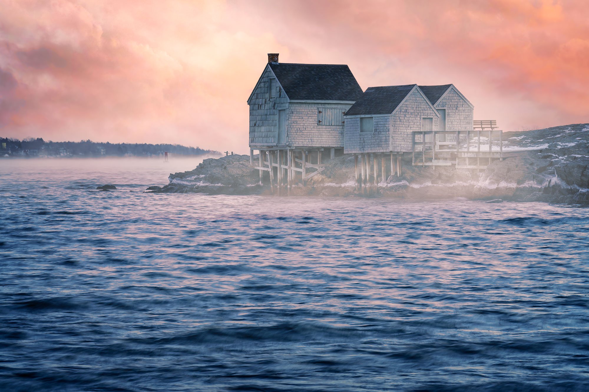
SANDWICH BOARDWALK
Sandwich, MA
Image by Matt Reynolds @ mattreynoldsphotography.com
This wonderful location is just a few miles from the Cape Cod Canal. The Sandwich Boardwalk is a 1,350 ft long wooden boardwalk that spans across a creek and marsh ending at Town Neck Beach in Sandwich.
Originally built in 1875 it has been rebuilt numerous times due to damage from various storms. Many of the wooden planks that make up the boardwalk are engraved with donor names/messages. The boardwalk, creek and surrounding marsh create ideal leading lines, and offer many compositional opportunities. While an enjoyable place to go for a walk anytime, I would consider this primarily a sunrise location and looks best with colorful clouds reflecting in the bodies of water.
Photos and location summary by Matt Reynolds
Trail Difficulty - EASY
I would rate the difficulty of this trail a 1-2 on a scale of 1-5 (with 5 being most difficult). It doesn’t get much easier in terms of access or difficulty rating. The boardwalk starts at a parking lot and you can be out of your car and shooting in a matter of minutes. Getting muddy is about the worst-case scenario, though it is imperative that you check the tide times before venturing out as the tides move in fast. While the physical danger is quite low, the chance of getting your gear wet is real. Marsh mud is also very slippery when wet.
Most of the marsh and surrounding area can be walked on, but at the end of the trail please stay on the boardwalk as it climbs the beach dunes. Those sand dunes are protected and no access is permitted.
Please respect all postage signage in the area.
What Lens(es) Do You Need
This location is primarily a wide-angle or normal focal length spot. The boardwalk or marsh can be used to create a nice foreground which can be emphasized with a wide-angle lens.
The main image above was a 6 shot vertical pano (each taken @ 21mm prime lens) - full frame camera, f11, and 1 second to smooth out the water and bring out optimal reflections. I used a circular polarizer and a 3 stop ND filter and the image was taken about 10 minutes before sunrise. My objective was to capture the curve of the water in the creek which is why I opted for the pano.
This is a great location to use filters / long exposure photography methods. This can often bring out more movement and color in the clouds as well as in the reflecting water.
Nuances of Shot
I mentioned above, the seasonal aspects, camera settings, choice of lens, etc…
I have not yet mentioned the importance of tidal conditions in regard to potential imagery. A higher tide will generally be optimal as the marsh areas look best when filled with water. The “shoulder season” time of year brings more importance to higher tides. While my preference would be for high tide, colorful clouds is more important than the tide (all of the images above were taken near low tide). I do think each of the presented images could look better in the same conditions but at high tide. Also, a still morning (not much wind) will aid in the stillness of the water in the creek and marsh areas, which does help with reflections.
The tidal differences can bring significant landscape changes to any location on the bayside of Cape Cod and I always recommend checking Cape Cod Tide Chart before you go.
While not important to photography, low tide can bring an …
Join Today
To View Full Location Summary
START YOUR NEXT ADVENTURE
2 Ways to Join
Annual Subscription
Lifetime Membership
Our location summaries are written by experienced photographers - with practical information for planning your adventure - and with tips to getting the best shot


GPS Coordinates & Elevation
Sea Level Ft. Elevation
Directions
CLICK HERE to get driving directions to the parking lot for Sandwich Boardwalk
There are actually 2 addresses (parking areas) for this location, and although there are about 2,000 ft between them, due to the marsh, it is a confusing 10-minute drive from one parking lot to the other.
The best address to use is the end of Boardwalk Rd. in Sandwich, MA. This is where the start of the boardwalk is and there is a large parking lot there. I recommend putting “Boardwalk Road, Sandwich, MA” into your GPS to get routed correctly, or follow the below steps:
Take Route 6A to Jarvis St. (on your left if from the Bridge or on your right if from further out on the Cape). Then take a left on Factory Street and a right on Harbor Street. Harbor Street turns …
Equipment Needed
A tripod is recommended (a tripod which allows you to set up very low and very high can give you some different perspectives).
Filters can be useful at this location for long exposures.
Prepare for some mud if you want to explore off the boardwalk itself. Tall waterproof boots are ideal but not required. Bug spray in the summer months is also recommended, not necessary for the rest of the year. Generally, any breeze will keep the critters away at this location.
Weather
Weather can be pleasant to cool in Fall and Spring and it can be hot in Summer (but nice and comfortable at sunrise). Winter can be very cold and bring snow and ice.
The close proximity of the parking makes cold weather less of a concern.
Download KMZ Trail File
Click Here to download the KMZ file for this location.
START YOUR NEXT ADVENTURE