
Doubling Point
DOUBLING POINT
Near Bath, ME
Image by Rick Berk @ www.rickberk.com
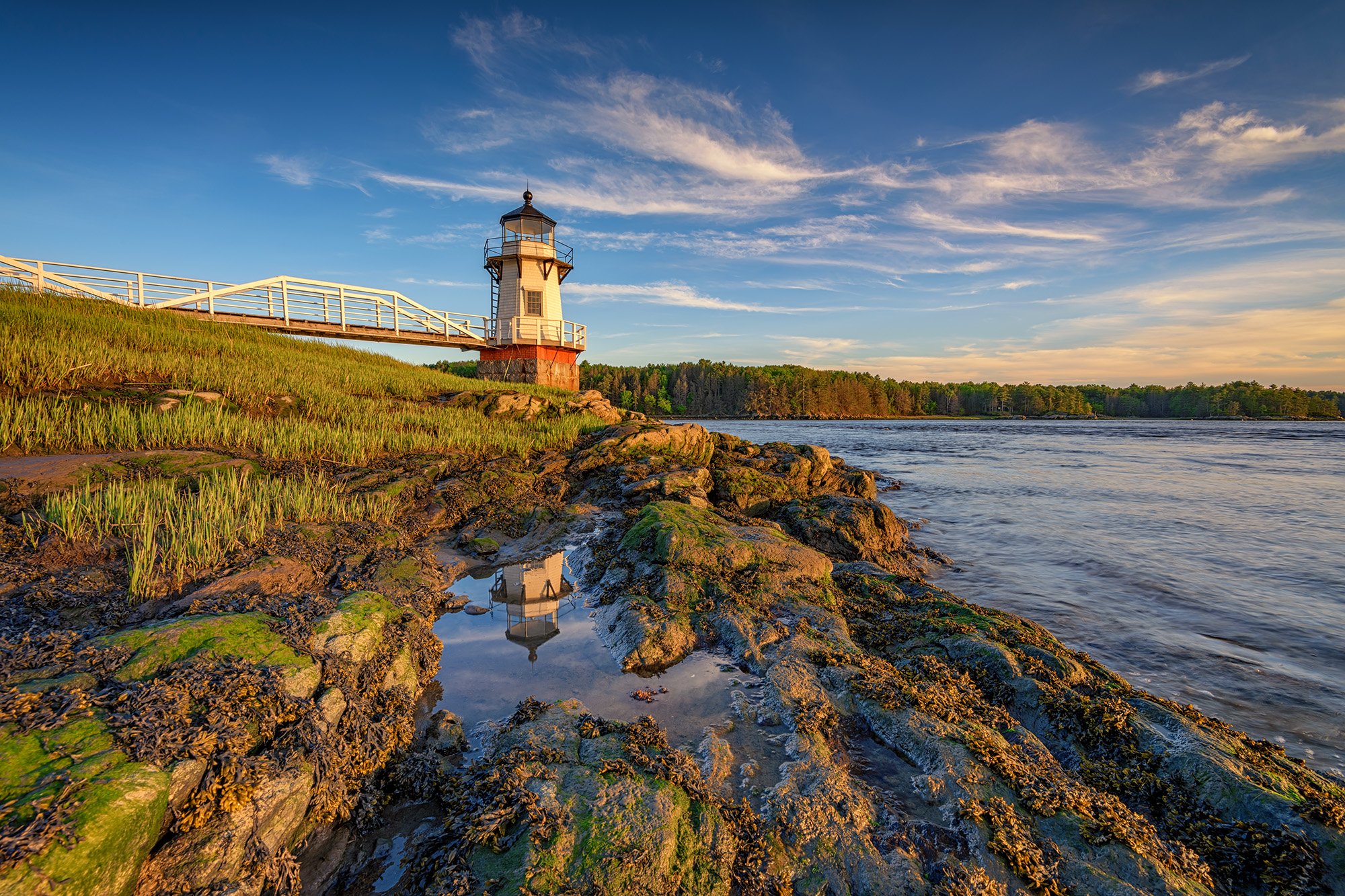
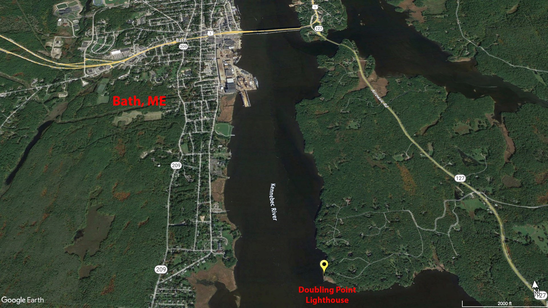
Doubling Point Lighthouse, located on the Kennebec River just downriver from Bath, Maine, was built in 1898 to help aid ships in navigation of a bend in the river as they sailed into Bath Iron Works, a major shipbuilder.
It was built at the same time as Squirrel Point Lighthouse, and features a keeper's house, shed, and oil house. The keeper's house is set away from the river's edge, among a stand of trees, and thus difficult to include in photos. The lighthouse is a popular stop for lighthouse enthusiasts and photographers.
IMPORTANT: There’s been a change to Doubling Point Lighthouse’s accessibility. Fairly recently, there have been signs put up that state visiting hours are between 9am and 5pm. They also have signs stating No Trespassing and that security cameras are in use. According to the website, you can email lighthouse@doublingpoint.org to get permission to be there outside of the stated hours.
Photos and location summary by Rick Berk
Trail Difficulty - EASY
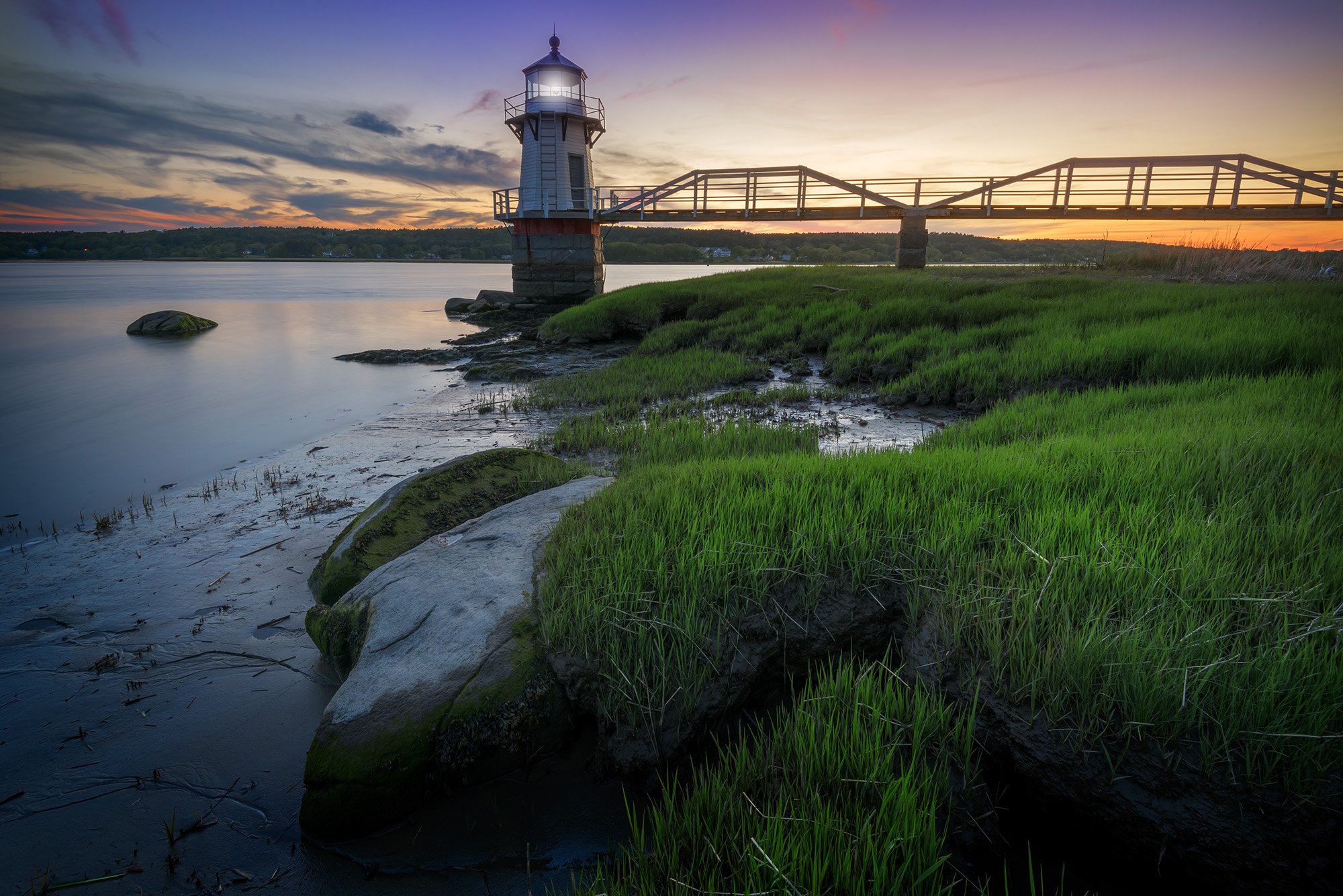
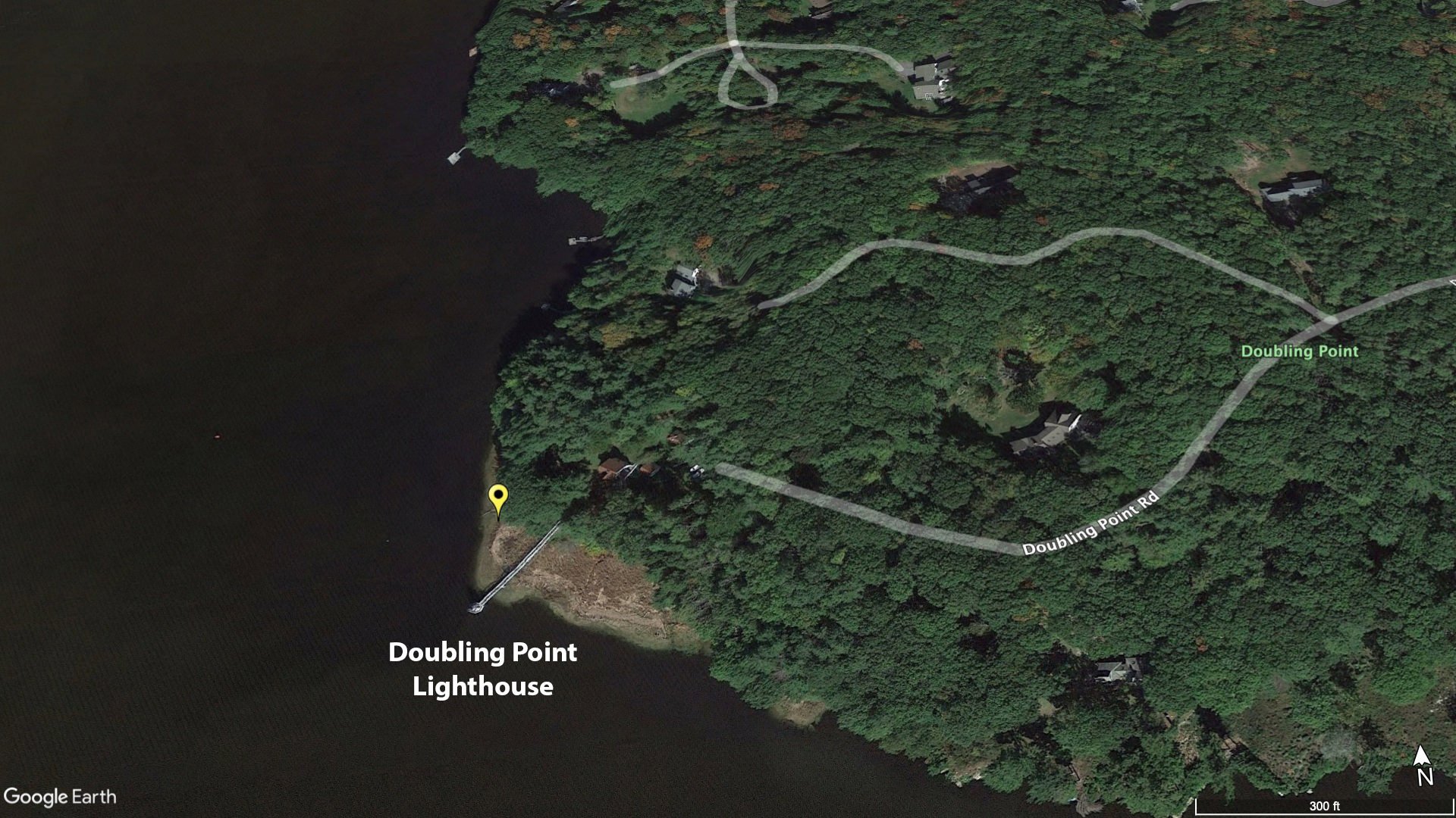
You can drive all the way up to the keeper's house, where there is parking for 3-4 cars. From there make your way down to the lighthouse. The trail is easy for the most part, but if you make your way into the grasses either north or south of the lighthouse, be aware that at times these areas are underwater. The Kennebec River is tidal in this area, and at extreme high tides those marshy areas are inundated, which means when the waters recede, thick mud and pools are left behind below the tall grass. Waterproof boots are recommended for venturing into these areas, which offer some of the best angles on the lighthouse.
GPS Coordinates & Elevation
Sea Level Ft. Elevation
View In Google earth
Directions
CLICK HERE to get driving directions to Doubling Point Lighthouse
From Bath, ME - drive east on US-1 and cross the Kennebec River and take ME-127 S to Whitmore's Landing Rd for 3.2 miles. Take a right on Doubling Point Rd and drive 1.2 miles. For the parking area to your shot.
Photography Tips
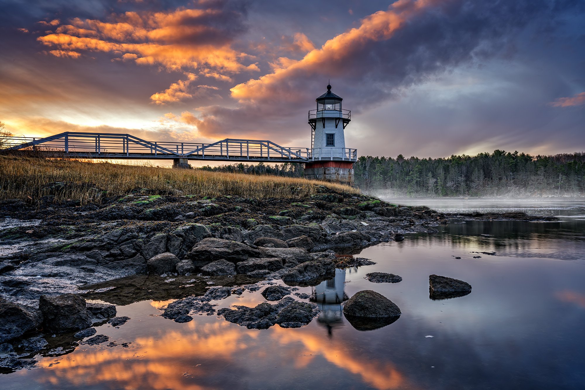
These were all taken at low tide, or as the tide was coming back in but not yet at high tide. This allows you to get down to water's edge and get a good angle on the lighthouse from the side. Check tide tables for Doubling Point to see what time the tides are.
Other images from Doubling Point
EXIF Data
Focal Length – 16 mm
Exposure – 10th sec @ f 8.0
ISO – 100
Date – May 30th
Time – 7:40 pm
Best Time of Day to Shoot
This location is good both at sunrise and sunset, but a little better at sunset. The sunset occurs over the river most of the year, allowing for a sunset image with the lighthouse in the foreground. At sunrise, the rising sun is behind the trees as you face south, which allows for good color in the sky but no direct light on the lighthouse itself.
Best Time of Year
From late spring through the summer, the sunset is visible from the south side of the lighthouse looking over the river, making for a dynamic composition. In the fall and winter, the sunset moves to the southwest, allowing for a composition from the north side of the lighthouse. However, in the late fall and winter, unless there is snow, the surrounding trees will appear dead and leafless.
The main image above was taken on May 30th
Lens(es) Needed
Wide angle and standard length lenses will work well here.
The main image above was taken at 16mm focal length.
Birds-Eye View
Permits
IMPORTANT: There’s been a change to Doubling Point Lighthouse’s accessibility. Fairly recently, there have been signs put up that state visiting hours are between 9am and 5pm. They also have signs stating No Trespassing and that security cameras are in use. According to the website, you can email lighthouse@doublingpoint.org to get permission to be there outside of the stated hours.
Direction of the Shot
The direction of the shot is south around 180°.
Equipment Needed
Other than a sturdy tripod, no special equipment is needed.
Number of Other Photographers to Expect
Few if any other photographers will be there.
Weather
The weather in Maine is often pleasant in the fall and spring. Mild in the summer and brutally cold in the winter.
Cell Service
I have Verizon and cell reception is good.
Nearby Restaurants
Pellentesque habitant morbi tristique senectus et netus et malesuada fames ac turpis egestas. Pellentesque consequat dapibus ex, a luctus sem porta ut. Donec vel placerat ipsum. Sed sed posuere metus, id vestibulum augue.
Nearby Restaurants - click on the restaurant below for yelp review
Bath Brewing Company
(207) 389-6039
141 Front St Bath, ME
Montsweag Farm Restaurant
(207) 443-6563
942 US Rte 1 Woolwich, ME
Area Guides and Workshops
Rick Berk (25 years as a landscape photographer) - offers private group, 1 on 1 and group workshops (BlueHour Photo Ventures) for the Maine and other northeast US area. Rick lives Freeport, Maine and has traveled and photographed the NE for most of his adult life. His outstanding work can be found at www.rickberk.com